| |
|
|
|
|
|||
 |
|
 |
|||||
| |
|||||||
|
|
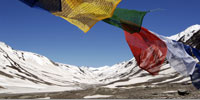
Stark terrain, powerful rivers, sparkling glaciers, green paddocks, weathered gorges and washed-out roads. The road from Manali to Leh provides a visual feast. The road is usually open end of June until late of September, depending on the snowfall. I decided not to rush with one of the 18 hour Jeep-trips and booked a ticket with the local bus. The journey took two days and we stopped once in Keylong (147km from Manali). We left Manali at 6 a.m. after gathering at the bus-station two hours before. The bus supposed to leave at four-thirty. I took it easy, what else can you do. The weather was great and the mountains around Manali looked majestic in the morning light. Because of Indian holidays (until end of June) and the fact that many Indians visit Rohtang La Pass (3980m) to touch snow for the first time in their life it was very busy. We were stuck for about 2 hours in between bus-high snow to the left and the right until we could pass Rohtang and proceed to Koksar, were foreigners had to register with the police. The descending road showed the bare and desolate valleys of Lahaul, shadowed by the peaks of the Lesser Himalayas. To the left I could see the valley towards Tandi, to the right the steep winding road to Kaza which just opened three days ago. It follows the Chandra River to its junction with the Bhaga opposite Tandi.
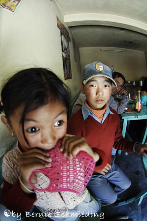
The road was very narrow and washed-out. We had to pass some waterfalls next to it and when I looked down to the left I could not even see the road anymore but the Chandra River 300m below. The colors in Lahaul are absolutely stunning. Blue sky, green fields, white snowy peaks and icy glaciers. I was surprised how green it actually was and many trees grew along the road and especially on the upper hills. After a ten hour drive we reached Keylong, which is almost on the same altitude then Leh in Ladakh. 3347m. Keylong is one of three villages that lie scattered around the confluence of Chandra and Bhaga River. It is a tiny village with a beautiful setting in midst the mountains. Take a room with a view to practice yoga in-front of the entire mountain-chain of the Bhaga valley. The village and fields of Khardong are opposite, the river below. Vegetables are grown on terraces along the steep hills. Keylong is the district headquarter of Lahaul-Spiti and there is even a bank here. My guesthouse was close to the bus-stand to get a good start when getting up next morning at a quarter to four to catch the bus to Leh. After a shower I was strolling down in to the village to grab something to eat. The Lama Tea Stall was a small Tibetian run place where I ate momos and a Thaka soup and the whole family was there. It was such an experience to eat momos and thaksa in this tea-stall. The family was absolutely great and we had a good time. I told a bit about Australia and they told me in a very broken english about Tibetian & Nepali dishes. The grandma was cleaning cucumbers from the fields and they all were enjoying to play around with the screen of the video-camera. They haven't seen anything like it before and were looking into the lens and the Lcd which I turned to them at the same time. Another proof that one can lead a happy and simple life. The children were chasing the dog and the little girl showed me how to eat the delicious momos. It was here that I should have my cheapest dinner in India. For the momos, soup and two excellent tasting teas they charged me 16 rupees. I could hardly believe it. From here on I decided to eat a lot more in local footstall's and small eateries as the contact with the locals is much more warm-hearted.
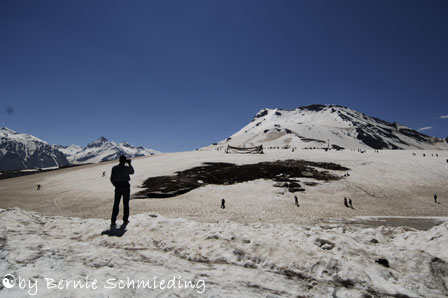
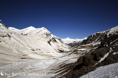
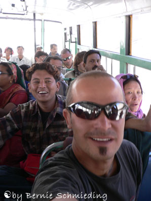
Day 2 brought us five hours of waiting-time at Baralacha-La, two flat tires and a frightening night-journey. Just after I woke up and got my things together a Tibetian boy from our bus invited me to drink a chai at the chai-stand next to the bus.We left Keylong way before sunrise and drove along the Bhaga River towards Darcha. Gravel and bitumen-road changed frequently and we could see yellow blooming fennel to the left. Golden mountain-peaks looked down at us in the warm morning-sun and bitter-cold creeks the bus had to pass. The full-moon was still at its peak. Passing Jespa and the wide and fertile banks of the Bhaga River I could see cows grazing while half of the bus fell asleep again. Suddenly the driver pulled the brake like hell. We almost run into a blue truck. Behind a curve the truck suddenly appeared. The roads are narrow (3m) in general and so the truck-driver had to reverse. From time to time overtaking-bays appear. First stop was at Koksar were foreigners had to produce the passport at the police-office (this was actually a tent). Listening to Morcheeba and staying in the bus we passed a shepherd and his goats and sheep. This local bus I took was the worst bus I have ever used, I can tell you. Sitting for a short time I had to stand up as the buttocks were hurting. That was actually not too bad. The worst was the contaminated air inside the bus. We were inhaling heaps of smoky gasoline fumes which somehow came from the front of the bus. The fumes produced a lot more headache than the change in altitude (from 2000 to 5400 during the trip). Great to see though what a good-time aboard the bus I had. Sharing my cashew-nuts, chocolate and sunflower-kernels brought us close together. The language problem wasn't any anymore. The Indians spoke Hindi with me and I answered in english. Somehow we got around. Amazing Parantha (bread with potatoes and oil) and a stunning sunrise for breakfast at Jispa Camps. Then the first roadsign " be gentle with my curves" as a first morning warning. Getting closer to Baralacha La a lot of army was to see. We reached the pass at 8.30 and could pass it five hours later due to a truck accident and our first tire-puncture. Down the pass were snowfields and gravel to the left and right. The Barcha river starts right here from a little lake fed by the ice-melting glacier.
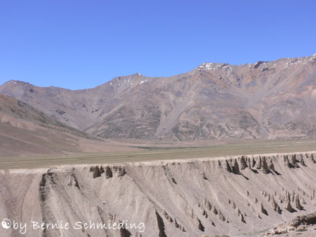
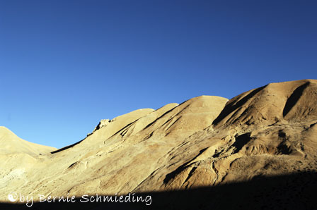
Entering the Ladakh Region of Jammu & Kasmir at Sarchu, deep gorges to the left of the road in mighty contrast to the snow-capped mountains and obscure pinnacles. Stopping to let a big army-convoy pass I was standing on cracked, desert-like bronze earth which hasn't seen water for long. Driving about 50km along the spectacular Lingti Chu River Valley and after overtaking several army trucks the road ascended steep to the 5060m high Lachlung La Pass. From the Pass, the road, often in very poor condition goes downhill to enter the unreal gorges of Pang. It was before sunset and the bronze mountains appeared almost golden against the pure blue sky. Registering at the army checkpost and fixing another tire set us back for an hour before we could continue the journey in the darkness towards Taglang La, the second-highest motorable road in the world.
Despite the cold in the bus two Tibetian children where laughing
and singing in the back of the bus while half of the passengers was asleep.
By now we were traveling for 15 hours and my bum was hurting - so I decided
to stand where there was some space. It took another five hours until
we reached Leh at 2 a.m. in the morning. The road up
and down from Tanglang La was hair-raising and the bus in front of us
almost flipped over, going thru a deep dip. We followed the bus with 2
to 10m distance...After the bus journey I got sick and my nose was completely
blocked with dust for a couple of days. This trip was absolutely
hardcore and next time I will use a Jeep. At this time of the
year the deluxe busses from Manali were not starting yet as the road had
just opened 10 days ago (15. June 2005). The interaction with the Indians
aboard the bus (we were 4 Foreigners only) was absolutely great and I
had a lot of fun. I will remember this trip for a long time, that's
for sure. This journey was strenuous and adventurous at the same
time.
|
|
|||||
| |
|
|
|
|
|
|
|